

EXPLORING NATURAL RESOURCES
Geothermal energy is heat derived within the sub-surface of the earth. A geothermal system is made up of four main elements: a heat source, a reservoir, a fluid, which is the carrier that transfers the heat, and a recharge area. Geothermal energy is a renewable source and can be used for heating and cooling purposes or be harnessed to generate clean electricity.
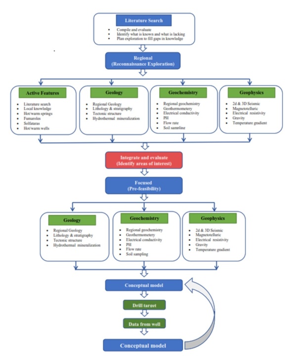
Geothermal system modeling:
The characterization and modeling of geothermal systems should verify these elements and processes. Geophysical surveys such as magnetotellurics (MT) and seismic can help to identify the location and size of the thermal water aquifer as well as the fracture/fault system along which cold water and hot water move to and from the aquifer, respectively. Geochemical analyses can provide useful information about the type of thermal water, enthalpy, and source of heat. Drilling exploratory wells can help to verify the geophysical and geochemical interpretation of the geothermal model. Natural Resource Unit of ARGAS is capable to provide facilities and experts to explore and evaluate the geothermal reservoir as follows:
The flow chart shows project stages with typical data acquired and integrated into the conceptual model.
Potential Geothermal Resource of Saudi Arabia:
Renewable energy, including geothermal resources, occupies a very advanced rank in the priorities of the Saudi 2030 promised vision document. Some aspect of power generation renewable resources is now in use. However, geothermal power plants are not yet installed in Saudi Arabia. KSA has potential geothermal energy resources in many parts of the kingdom.
MINERAL EXPLORATION
Mineral exploration is the process of searching for evidence of any mineralization hosted in the surrounding rocks. The general principle works by extracting pieces of geological information from several places and extrapolating this over a larger area to develop a geological picture. Mineral exploration includes several methods and techniques to find new mineral deposits. The Natural Resource Unit of ARGAS is capable to provide facilities and experts for the mineral exploration techniques and methods as follows:
Remote Sensing and Geographical Information System
Exploration Geophysics
Exploration Geology
Exploration Geochemistry
Drilling
Mineral Resource and Ore Reserve Estimation
Remote sensing is the science of acquiring information about the Earth's surface without being in contact with it. Reflected or emitted energy is sensed, recorded, processed, analyzed, and applied to gather that information. The images generated in remote sensing are broadly utilized for mineral exploration in mapping the geological features and lineaments and identifying rocks by their spectral signature. Images are gathered either through synthetic aperture sensors or optical sensors. Synthetic aperture sensors can sense electromagnetic data by transmitting microwaves and receiving the reflected back waves from the Earth’s surface while optical sensors measure the spectral data of sunlight reflected from the surface of the Earth.
MINERAL CHARACTERIZATION
Mineral characterization involves the study of minerals in terms of their size, chemical composition, morphology, textural position, and association. ARGAS and its partner are capable to provide these tests.
Petrography
Mineralogy
Geochemistry
Grain-Size Distribution
Petrography is a branch of petrology that focuses on detailed descriptions of rocks. The mineral content and the textural relationships within the rock are described in detail. Petrographic descriptions start with the field notes at the outcrop and include a macroscopic description of hand specimens. However, more detailed petrographic investigations with different magnifications are carried out on the laboratory scale including optical microscope (OM), Scanning Electron Microscope (SEM), Electron Prope Microanalyzer (EPMA), and Transmission Electron Microscope (TEM).
OIL & GAS
The evaluation of source rocks includes the quality by measuring total organic carbon (TOC), maturation, and kerogen type. The Natural Resource Unit of ARGAS is capable to provide facilities and experts for the evaluation of source rock in the petroleum system as follows:
Illite Crystallinity (IC)
TOC Analysis
Pyrolysis (Rock Eval)
Vitrinite Reflectance
Elemental Analysis
Illite crystallinity is measured using the Kibler Index (KI), which is the full width at half-maximum height (FWHM) of the illite 10-A X-ray diffraction (XRD) peak, measured on the ˂ 2mm size fraction of an air-dried clay specimen using CuKa radiation.
IC = 0-0.25 °2θ, it corresponds with a metamorphic epizone or greenschist facies.
IC = 0.25-0.30 °2θ, it corresponds with metamorphic high anchizone facies.
IC = 0.30-0.42 °2θ, it corresponds with metamorphic low anchizone facies.
IC = 0.42-1.0 °2θ, it corresponds with metamorphic deep diagenetic facies.
IC is > 1.0, it corresponds with metamorphic shallow diagenetic facies.
GEOLOGICAL MAPPING
Geological mapping is the process of a geologist physically going out into the field and recording geological information from the rocks that outcrop at the surface. Information will include boundaries between different rock types and structures, and evidence of the rocks undergoing deformation. When conducting mapping for mineral exploration, the geologist will be keeping an eye out for ore minerals, evidence of metal-rich fluids passing through the rock, and recording mineralised veins and their distribution. Mapping requires several steps that RGAS is capable for them as follows:
Remote Sensing
Geological Observations
Geochemical Methods
Geophysical Surveys
The Remote sensing technology and satellite products provide the fast access to all geospatial data. Also, a greater and finer resolution of data and images are readily available in planimetric and 3-D mode at any desired scale and time. These data can be integrated with Geographic Information Systems (GIS) for vertical and horizontal comparison.
GEOTECHNICAL INVESTIGATIONS
Geotechnical investigations are performed to obtain information on the physical properties of soil earthworks and foundations for proposed structures and for repair of distress to earthworks and structures caused by subsurface conditions. This type of investigation is called a site investigation. A wide variety of laboratory tests can be performed on soils to measure a wide variety of soil properties. ARGAS and its partners are capable to carry out these tests as follows:
Atterberg Limits
California Bearing Ratio
Direct Shear Test
Expansion Index Test
Hydraulic Conductivity Tests
Oedometer Test
Particle-Size Analysis
R-Value Test
Soil Compaction Tests
Triaxial Shear Tests
Unconfined Compression Test
Water Content
The Atterberg limits define the boundaries of several states of consistency for plastic soils. The boundaries are defined by the amount of water a soil needs to be at one of those boundaries. The boundaries are called the plastic limit and the liquid limit, and the difference between them is called the plasticity index. The shrinkage limit is also a part of the Atterberg limits. The results of this test can be used to help predict other engineering properties.
CARBON CAPTURE & STORAGE
Carbon capture and storage (CCS) or carbon capture and sequestration is the process of capturing carbon dioxide (CO2) before it enters the atmosphere, transporting it, and storing it (carbon sequestration) for centuries or millennia. Geo-sequestration involves injecting CO2, into underground geological formations. Subsurface monitoring can directly and/or indirectly track the reservoir’s status. Subsurface monitoring of CCS includes:
Seismic
InSAR
Drilling
It is done by creating seismic waves either at the surface using a seismic vibrator, or inside a well using a spinning eccentric mass. These waves propagate through geological layers and reflect back, creating patterns that are recorded by seismic sensors placed on the surface or in boreholes. It can identify migration pathways of the CO2 plume.
HYDROGEOLOGY
The major intention of geophysics applied to hydrogeology is to deliver parameters and subsurface models, which are helpful for the decision-making process in groundwater exploration and groundwater protection. To address these two major purposes, groundwater geophysics can have the following four basic aims:
- Discrimination of water-bearing rock from non-water bearing rock (Exploration)
- Delineation of the dimensions of an aquifer (Exploration, Protection)
- Delineation of preferential groundwater flow paths (Exploration, Protection)
- Existence and thickness of impermeable overbuy the distribution of the hydrological parameters porosity and permeability.
Several geophysical methods are used for hydrogeological surveys that can be provided by ARGAS and its partners.
Magnetic (or geo-magnetic) Techniques
Gravity Method
Electrical Method
Seismic
Ground Penetrating Radar (GPR)
The main use for regional groundwater investigations has been as part of combined surveys with gravity for defining large-scale basin structures. Magnetic surveys are also often used to locate the cause of contaminated groundwater by surveying for buried metallic objects such as hydrocarbon storage tanks, and chemical containers, however these uses are not discussed further. Magnetic surveys have also been used to identify basement faulting and other locations of crustal weakness that may represent preferential fluid flow paths.